NSGN Deployment Plan
The new NSGN will be comprised of integrated, multi-technique next generation space geodetic observing systems, as the core contribution to a global network designed to produce the higher quality data required to maintain the Terrestrial Reference Frame and provide information essential for fully realizing the measurement potential of the current and coming generation of Earth Observing spacecraft. To achieve the desired level of accuracy and stability, the NSGN Sites will co-locate and use in unison several key techniques of observation, including: VLBI, SLR, GNSS, and DORIS. Other complementary instruments, such as gravimeters, may also be collocated at the sites, but are not part of the baseline NSGN architecture. The measurements derived from the various techniques at each site must be combined to produce the ITRF. To improve this combination, each NASA site will include a Vector Tie System (VTS) that monitors the local-ties (relative positions) between the different geodetic stations, ensuring available and timely site-tie updates.
SGP is implementing NASA’s response to the US National Research Council (NRC) Committee on the National Requirements for Precision Geodetic Infrastructure recommendations by sustaining and operating NASA’s legacy Space Geodesy Networks while executing the construction, deployment, and operation of the next generation Space Geodesy stations as part of a new NSGN. The SGP deployment strategy is guided by the NRC recommendations as well as the plans of other nations for contributing to the Global Geodetic Observing System (GGOS). The SGP is currently planning the construction of up to ten new or upgraded geodetic sites that are chosen to fill in the gaps of the global network.
The functional design of NASA’s next generation stations and sites is based on the prototype core site located at NASA’s Goddard Geophysical and Astronomical Observatory (GGAO) at the Goddard Space Flight Center (GSFC) in Greenbelt, Maryland. A block diagram of a typical NSGN site is shown below.
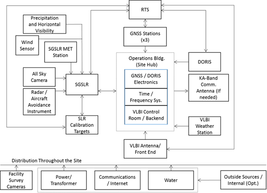
Typical NSGN Site Block Diagram
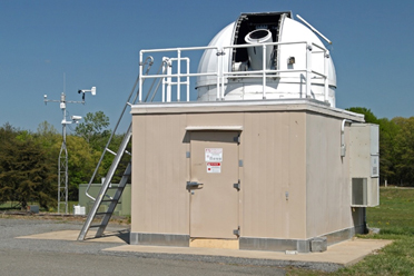
NGSLR protoype station at GGAO
The Next Generation SLR (NGSLR) prototype was originally built for eye-safe automated laser ranging. The development was originally focused more on saving operational costs than on data quality. Over time, the requirement to track daylight GNSS was added that required laser energies that no longer made the system eye-safe. Millimeter quality requirements were also added to the precision and stability of the system. Modifications to NGSLR for these new requirements were started in 2011 and the new system performance was demonstrated in 2013. Some of the key performance requirements that were demonstrated include: 1 mm normal point precision on LAGEOS, ground calibration stability at the 1mm level over hour, and daylight tracking of GNSS satellites.
The Space Geodesy Satellite Laser Ranging (SGSLR) systems that will be deployed as part of the NSGN are based upon the NGSLR design with modifications for full automation and incorporation of lessons learned from the prototype development, testing, and operations. Significant changes from the NGSLR prototype are: (1) full automation, (2) use a standard on-axis Cassegrain telescope (rather than the off-axis optical system used on NGSLR), (3) purchase the telescope and gimbal from the same manufacturer and let the single vendor be responsible for meeting all gimbal/telescope requirements, (4) simplify the design where possible, and (5) modify the optical configuration to improve in-field system troubleshooting, operational performance and minimize the stray light backscatter.
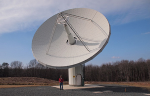
Broadband VLBI prototype antenna at GGAO
A fast-pointing 12-meter VLBI antenna was also installed at GGAO and a broadband signal chain was developed and implemented to meet the VLBI2010 specifications. The new system performance was demonstrated in 2013. A joint NASA-USNO VGOS station was then developed and implemented at Kōkeʻe Park Geophysical Observatory (KPGO) based upon the GGAO prototype design with modifications from the lessons learned. The VGOS station at Texas will also be based on the GGAO and KPGO design with minor modifications from lessons learned.
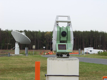
The Robotic Total Station at GGAO that is part of the site’s Vector Tie System
The VTS is a combination of precise local-tie surveys and a periodic monitoring system using one or more Robotic Total Stations (RTS) and other instrumentation (tilt meters, etc.) for measuring the site stability. The GGAO implementation demonstrated the ability to monitor the site semi-autonomously with sub-millimeter accuracy. This included the ability to find and identify the target prisms, verify the prism correction, and process distance measurements to correct for atmospheric conditions.
Two new GNSS stations, GODN and GODS (Goddard North and South), were also installed at GGAO and have been delivering data since January 2012. The stations are multi-constellation (i.e., they are compatible with GPS, GLONASS, and Galileo). A comparison of the GNSS measured GODN-GODS baseline length to the VTS measurements was found to be in agreement at the sub-millimeter level. New GNSS stations at NSGN sites will also be modern commercially available multi-constellation systems that meet the IGS standards.
The DORIS beacon at GGAO has been operating since June 2000 as part of the global DORIS network of ~57 stations. The beacon transmits at 2 GHz and 400 MHz, observable at satellites equipped with DORIS receivers. The implementation of DORIS beacons at NASA sites will depend upon the requirements of the DORIS network and coordination with CNES and IGN.
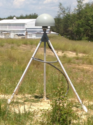
The South GNSS station (GODS) at GGAO
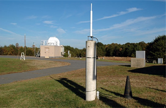
The DORIS beacon at GGAO
The NSGN systems are being developed with a goal of greater than 10 years of operation. The modular designs enable ease of maintenance and technology upgrades. The Space Geodesy Network Operations Center (SGNOC), as shown below, will be developed to take advantage of the high level of automation of the new systems and provide for centralized network operation.
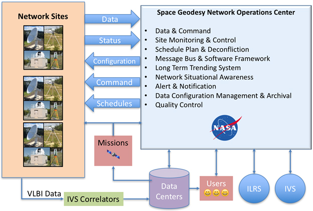
The Space Geodesy Network Operations Center will take advantage of the high level of automation of the new systems and provide for centralized network operation.