Science and Applications
Geodesy is the science of the Earth’s shape, gravity and rotation, including their evolution in time. A number of different techniques are used to observe the geodetic properties of the Earth including the space-geodetic techniques of Very Long Baseline Interferometry (VLBI), Satellite Laser Ranging (SLR), Global Navigation Satellite Systems (GNSS) like the US Global Positioning System (GPS), and the French Doppler Orbitography and Radio-Positioning by Integrated Satellite (DORIS) system. These space-geodetic observations also provide the basis for the reference frame that is needed in order to assign coordinates to points and objects and thereby determine how those points and objects move over time.
Improving the performance of the Global Geodetic Observing System (GGOS) and the ITRF is critical to understanding the future impact of sea level change. The GGOS geodetic reference frame requirement for sea level measurement is 1 mm reference frame accuracy and 0.1 mm/year stability. From: National Research Council. Precise Geodetic Infrastructure: National Requirements for a Shared Resource. Washington, DC: The National Academies Press, 2010.
The Terrestrial Reference Frame (TRF) is the foundation for virtually all airborne, space-based and ground-based Earth observations. Through its tie to the Celestial Reference Frame (CRF) by time-dependent Earth orientation parameters, it is also fundamentally important for interplanetary spacecraft tracking and navigation. The TRF determined by geodetic measurements is the indispensable foundation for all geo-referenced data used by society. It plays a key role in modeling and estimation of the motion of the Earth in space, in measuring change and deformation of all components of the Earth system, and in providing the ability to connect measurements made at the same places at different times, a critical requirement for understanding global, regional and local change.
Space geodesy has revolutionized the study of solid Earth processes through its ability to measure the deformation of the Earth’s surface and the Earth’s gravity field with extraordinary accuracy. These provide information about the motion of the Earth’s tectonic plates, insight into the cause and timing of earthquakes and volcanic eruptions, and constraints on the internal forces that drive them. Understanding the complex Earth system requires integrated and geo-referenced sets of observations on global to regional spatial scales and with high spatial and temporal resolution.
Modern geodetic measurements are making fundamental contributions to mitigating the impact of geohazards such as earthquakes, volcanic eruptions, debris flows, landslides, land subsidence, sea level change, tsunamis, floods, storm surges, hurricanes and extreme weather. The ability to relate measurements to one another in both space and time depends on knowledge of the terrestrial reference frame in which the measurements are made.
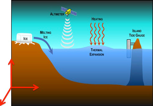
Geodesy is at the heart of all present day ocean studies. It is the means by which the orbit reference is computed for analysis of all satellite altimeter data, and the accuracy with which that data can be tied to tide gauge and other data. Knowledge of the reference frame geo-center and its change are needed to study regional and global sea level change and ocean-climate cycles like El Niño, the North Atlantic Oscillation, and the Pacific Decadal Oscillation.
Space Geodesy provides positioning, navigation, and timing reference systems and Earth system observations
Geodesy contributes to atmospheric science and hydrological studies. It supports both observation and prediction of the weather by (1) geo-referencing meteorological observing data, (2) providing atmospheric weather models with space- and time-varying gravity fields, and (3) globally tracking change in stratospheric mass and lower tropospheric water vapor fields. Geodesy also provides a unique global reference system for measurements of: sub-seasonal, seasonal and secular movements of continental and basin-scale water masses; the wet part of the troposphere from atmospheric sounding; loading and un-loading of the land surface due to seasonal changes of groundwater; local measurement of the integral variation of ground water from permanent gravimetric tidal stations; measurement of water level of major lakes and rivers by satellite altimetry; improved digital terrain models, as basis for flux modeling of surface water and flood modeling; geographic information systems for the establishment of comprehensive referenced data modeling.