Project News
 Complete Dataset from the Apache Point Lunar Laser Ranging Station Released
04/17/2024In February 2024, NASA published a set of normal points from the Apache Point Lunar Laser Ranging Station to the NASA Crustal Dynamics Data Information System (CDDIS) spanning the entire operations of the station, April 2006 through mid-January 2024. This timespan includes data prior to NASA taking over stewardship of the station that was not previously released in part due to ongoing development of software related to the Absolute Calibration System (ACS) that was installed in late 2016. NASA stewardship of the station helped continue and complete the ACS software development, which prompted a re-processing of all the data to improve its accuracy.
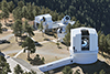
 The Navy and NASA are jointly preparing an Environmental Impact Statement (EIS) for state lands at PMRF and KPGO
12/15/2023The Navy and NASA are jointly preparing an Environmental Impact Statement (EIS) to evaluate the potential impacts of real estate agreements with the State of Hawai'i, Department of Land and Natural Resources (DLNR) for state lands at PMRF and KPGO. The Navy and NASA encourage the public to participate in this environmental review process. The Navy and NASA will be initiating a public scoping period and holding public meetings in early 2024. The public can participate during the public scoping period by providing input on the proposed real estate action and issues to be considered in development of the EIS.
View fact sheet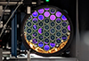 NASA Laser Reflecting Instruments to Help Pinpoint Earth Measurements
12/08/2023The best known use of GPS satellites is to help people know their location whether driving a car, navigating a ship or plane, or trekking across remote territory. Another important, but lesser-known, use is to distribute information to other Earth-viewing satellites to help them pinpoint measurements of our planet.
NASA and several other federal agencies, including the U.S. Space Force, U.S. Space Command, the U.S. Naval Research Laboratory, and the National Geospatial-Intelligence Agency are improving the location accuracy of these measurements down to the millimeter with a new set of laser retroreflector arrays, or LRAs.
"The primary benefit of laser ranging and LRAs is to improve the geolocation of all of our Earth observations," said Stephen Merkowitz, project manager for NASA's Space Geodesy Project at NASA's Goddard Space Flight Center in Greenbelt, Maryland.
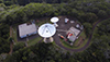
Read more on nasa.gov... The National Geodetic Survey posts the results of their May 2023 local tie survey at the NASA Kōkeʻe Park Geophysical Observatory (KPGO)
10/26/2023The National Geodetic Survey posted the results of their May 2023 local tie survey at the NASA Kōkeʻe Park Geophysical Observatory (KPGO). The survey establishes high-precision local tie vectors between the geodetic stations and their associated reference marks. Data collection consisted of terrestrial observations with an absolute laser tracker system, a total station, and survey-grade GNSS instrumentation. The local relationships were aligned to the International Terrestrial Reference Frame at the epoch date of the survey, ITRF2020 (2023/05/13). The survey results, report, and SINEX file are available at the NGS website: https://www.ngs.noaa.gov/corbin/iss/index.shtml.
 IVS Holds Technical Operations Workshop at MIT Haystack Observatory
05/16/2023From April 30 through May 5, the IVS held the twelfth installment of its Technical Operations Workshop (TOW) at MIT Haystack Observatory in Westford, MA, USA. Some 60 participants from 15 countries attended this first in-person TOW after the coronavirus pandemic. The TOW provided hands-on training for the technical staff of the VLBI stations. Over the course of the week, the students attended about 30 different workshops, seminars, and lectures covering topics as diverse as VLBI basics, session pre-checks and operations, cryogenics, RFI, phase calibration, and backend operations, to name just a few. SGP personnel were strongly involved in the organization of the workshop as well as in the teaching of several of the classes. Dirk Behrend was responsible for the overall organization, including class program and assignments, and he led through the workshop. Heidi Johnson took care of the local organization. The following SGP staff members served as instructors: Mario Bérubé (VLBI Communications Center), Pedro Elosegui (VLBI Basics), Rick Hambly and Katie Pazamickas (Time and Frequency), Frank Lemoine (Science Overview), John Swoboda (RFI), Chet Ruszczyk (VGOS Signal Chain, Mark 6, R2DBE), Mike Poirier and Alex Burns (Session Pre-checks, Failure Recovery), Ganesh Rajagopalan (Phase Cal), and Jason SooHoo (Data Transport). More information can be found on the workshop website at https://www.haystack.mit.edu/tow2023/.
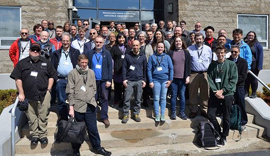
Group photo of workshop attendees. (Credit: Dirk Behrend)
 "Leaders in Lidar" Video Series
02/03/2023For those interested in the Legacy of Goddard's lead role in laser altimetry, you can view the recently released "Leaders in Lidar" Series (All Episodes – Youtube).
"In this series, we dive into the legacy of Goddard's lead role in developing laser altimetry, which has revolutionized the way we map our planet, the Moon and other planets. Each chapter looks at the successes and failures of these lidar instruments, beginning with the Mars Observer Laser Altimeter in the late 1980s, through the current generation of laser altimeters on ICESat-2 and GEDI. Through dozens of interviews and archival footage, the history, challenges and legacy of lidar are uncovered."
https://www.youtube.com/watch?v=w06s8x-0smE