What is VLBI?
Over its 40-year history of development and operation, the space geodetic technique called very long baseline interferometry (VLBI) has provided an unprecedented record of the motions of the solid Earth. VLBI is unique in its ability to define an inertial reference frame and to measure the Earth's orientation in this frame. Changes in the Earth's orientation in inertial space have two causes: the gravitational forces of the Sun and Moon and the redistribution of total angular momentum among the solid Earth, ocean, and atmosphere. VLBI makes a direct measurement of the Earth's orientation in space from which geoscientists then study such phenomena as atmospheric angular momentum, ocean tides and currents, and the elastic response of the solid Earth.
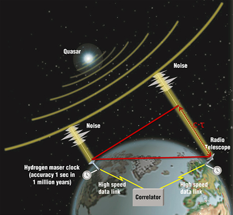
VLBI is a geometric technique; it measures the time difference between the arrival at two Earth-based antennas of a radio wavefront emitted by a distant quasar. Using large numbers of time difference measurements from many quasars observed with a global network of antennas, VLBI determines the inertial reference frame defined by the quasars and simultaneously, the precise positions of the antennas. Because the time difference measurements are precise to a few picoseconds, VLBI determines the relative positions of the antennas to a few millimeters and the quasar positions to fractions of a milliarcsecond. Since the antennas are fixed to the Earth, their locations track the instantaneous orientation of the Earth in the inertial reference frame. Relative changes in the antenna locations from a series of measurements indicate tectonic plate motion, regional deformation, and local uplift or subsidence.
The heritage of VLBI is 40 years of NASA-led technology development that included the highly successful Crustal Dynamics Project, during which the first contemporary measurements of tectonic plate motion were made. Today VLBI observations, analysis and development are coordinated by the International VLBI Service for Geodesy and Astrometry (IVS), comprising some 80 components (including 45 antennas) sponsored by 40 organizations located in 20 countries. The IVS Coordinating Center is located at Goddard Space Flight Center in Greenblet, MD. VLBI determines with unequaled accuracy the terrestrial reference frame (antenna locations on the Earth), the International Celestial Reference Frame (quasar positions on the sky), and Earth's orientation in space. In the future, VLBI development will continue in measurement systems technology, research on the neutral atmosphere, and integration with other space geodetic techniques.
VLBI is a valuable asset in NASA's mission of science-driven technology leadership. Earth science research requires VLBI's Earth orientation data coupled to a stable, accurate terrestrial reference frame.
The VLBI technique
To learn more about VLBI, see the presentations and video lectures from the 3rd IVS Training School on VLBI for Geodesy and Astrometry.
More information on VLBI activities at GSFC can be found here.