Laser Ranging - Satellite (SLR) and Lunar (LLR)
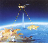
SLR tracking of altimetry satellite
Laser ranging uses ultra-short pulse lasers to measure the instantaneous round-trip time-of-flight from ground stations to orbiting targets equipped with special retroreflectors. Laser ranging can be performed to Earth-orbiting targets (Satellite Laser Ranging, SLR) and to targets on the Moon’s surface (Lunar Laser Ranging, LLR). SLR provides unambiguous range measurements to mm precision that can be aggregated over the global network to provide very accurate satellite orbits, time histories of station position and motion, and many other geophysical parameters. SLR operates in the optical region and is the only space geodetic technique that measures unambiguous range directly. It supports satellites from 300 km to geosynchronous altitude and provides data to users in near real time. A few stations in the global laser ranging network are LLR-capable, tracking routinely the retroreflectors on the moon and transponders on lunar satellites.
SLR is the most accurate technique currently available to determine the geocentric orbit of an Earth satellite, allowing for the precise calibration of radar altimeters and separation of long-term instrumentation drift from secular changes in ocean topography. Through its determination of the Earth’s center of mass and scale, SLR is a primary contributor to the International Terrestrial Reference Frame (ITRF). SLR’s ability to measure the temporal variations in Earth’s long-wavelength gravity field, to monitor network motion with respect to the geocenter, and to monitor height changes in an absolute system, makes it unique for monitoring long-term climate change by contributing to the definition a reference frame for post-glacial rebound, sea level and ice volume change, determining the temporal mass redistribution in the solid Earth, ocean, and atmosphere system, and monitoring the response of the atmosphere to seasonal variations in solar heating. SLR provides a unique capability for verification of the predictions of the Theory of General Relativity and other fundamental physics theories.
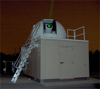
NGSLR system
Most of the present SLR ground systems (legacy systems) operate at 532 nm in the 5 – 10 Hz regime. Newer technology systems are now operating in the kilohertz region using photon-counting techniques that have greatly enhanced data productivity and pass interleaving capability. Automation of operations is also playing a larger role now as the candidate targets proliferate with the launch of several new navigation constellations that require orbit calibration with SLR tracking. The NASA Next Generation SLR system (NGSLR) is a prototype system that embraces the new technology and is being built as a prototype test-system that could lead into production units for network deployment as part of future core sites.
SLR stations operate as part of a global network organized under the International Laser Ranging Service (ILRS), a Service of the IAG (International Association of Geodesy). The Service includes over 40 stations, all co-located with GNSS and some with VLBI and DORIS. The ILRS sets the standards for network operation, it collects and validates the data and makes it available to users through its two official Data Centers at CDDIS (Goddard) and EDC (DGFI).
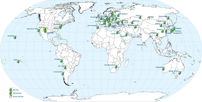
Current International Laser Ranging Service (ILRS) network
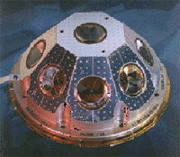
Satellite laser ranging retroreflector array
The space segment is an array of retroreflectors that significantly increase the optical cross-section of the satellites. The properties of the array depend on satellite altitude and application. Low Earth active satellites use arrays with symmetrically mounted cubes on a hemispherical assembly to provide return signal over a wide angular aspect.
Geodetic satellites have high mass-to-area ratio, are passive spherical satellites, covered with retroreflectors. This geometry makes the range correction to the satellite center of mass independent of satellites orientation. The current suite includes Low Earth Orbiting or LEO (e.g. Starlette, Stella, Larets, etc), MEO (e.g. Lageos 1 & 2), and high orbiting (e.g. Etalon 1 & 2). GNSS satellites in High Earth Orbits (HEO) and above (including the Moon) use flat arrays.

LAGEOS satellite
Work is also underway using spaceborne optical receivers (transponders) to extend the ranging capability to planetary distances. Additional information on SLR and LLR can be found at: http://ilrs.gsfc.nasa.gov/index.html